Tuesday, May 22, 2012

Of the city walls of Beijing;

I continued my morning jet-lagged walk around Beijing and found a section of the old city walls. China loves big walls. Everyone knows of the Great Wall of China, but there are so many other walls in China. Many old cities of China have segments of the past defensive walls still standing. Beijing's wall system mainly dates to the 1400s, but over the 20th century there were slowly dismantled to make way for railroads and an inner-city freeway. Now, all that remains are a few sections of wall with several gate and watch towers scattered around the city.


This is the Dongbianmen section of the wall I visited. You can see the restored wall section and the watchtower in the background.
A map of Beijing's old defensive wall system with the Dongbianmen wall section I saw marked.
Some areas of the wall have been restored while others are kept in a crumbling state. The section I visited had a large area which had been made safe to walk atop and an old unrestored section that stretched for another mile through the city. Most noticeable is the 30 meter high watchtower which was first built in 1440. It was a large defensive tower built at the Southeast corner of the city walls. In the past it would have been filled with hundreds of archers ready to fire arrows out from its 144 square windows. Today it is a museum about the city walls of China.

China's largest corner tower.
The same watchtower in 1895. What was once a moat along the wall, is now a small park.
A 1900-1930 shot of the tower with a camel train.

A view looking down the unrestored section of the wall.
The backside of the watchtower.
The walls of Beijing kept invaders out of the city for centuries. It wasn't until the 20th century that walls were taken by foreign armies. In response to the anti-European Boxer Rebellion in China, in 1900 an army of eight European and American armies attacked Beijing. The city walls held for two days against the cannons and 20,000 Anglo troops. The troops overran the wall and entered the city where they looted, raped, and killed before capturing the city and forcing China to pay the equivalent to $60 billion in war reparations.

An American painting showing the August 14th, 1900 Allied Relief Expedition assault on the outer walls of Peking.
A Chinese cannon on the restored wall section.
The damaged tower after several days of bombardment.
When the Anglo forces took over this section of the wall they carved their names and dates into the walls bricks. The Chinese call it "criminal evidence left by the Russian and American invaders."
One of the buildings on the wall.
After the Anglo invasion in 1900 arches were cut into the wall to open the city up to the growing rail system.


Monday, May 21, 2012

Of Beijing and dealing with Jetlag;

I set off for China with my big backpack crammed full of a few changes of clothes, power adapters/chargers, a potpourri of just-in-case medicines, and one large University of Washington Marching Band uniform. I guess I'm not the most efficient packer, but I was mainly happy that I didn't have to deal with hauling my heavy tenor sax around China with me. My flight was direct to Beijing from Seattle so all I had to deal with was a 12 hour flight and time zone change of 15 hours.
As we flew over Alaska I was able to get some good views of the Eastern Aleutian Mountain Range from my window.
I arrived to a wet and rainy Beijing evening. It was easy getting from the airport to the correct subway stop to find my hostel, but after I getting back up to street level I was completely lost. Since it was dark and cloudy I couldn't figure out which direction was north. All I could do was show people the Chinese characters for the address of my hostel and go the direction they pointed me in. I also discovered how hard it can be to cross the street in China. Cars don't really stop for pedestrians in China so you have to plan out how you'll get across there street. Sometimes you can make it across quickly, but other times you'll end up standing in the middle of the road with cars buzzing by on either side of you.


Eventually I found my way to the SanLiTun Youth Hostel and got myself checked in. By this point it was about 8:00 PM and I was dead tired from my long flight and the 15 hour jump of timezones. I went down to the hostel's common room/bar to get a beer and chat with the other travelers. A got a bunch of suggestions of which places are worth seeing in Beijing, but it wasn't long before my eyes were slowly closing due to my lack of sleep and jetlag.

I'm not sure how big of a problem firecrackers are, but I saw a lot of these signs in China.

I woke up the next morning wide awake at 5:30 AM and could not get back to sleep. I got up and prepared my little daypack with maps, cameras, and my Lonely Planet China guide before heading out to see the city. It was still early, but since the rain from the previous day took down all of the smog, it was clear and sunny out.

Breakfast street food! It is a crispy fried pancake with and egg cracked and fried on it. With a sauce, meat, and lettuce inside. It was really good.
From my hostel I started walking south and got to Ritan Park also known as the Altar of the Sun. It was first built in 1530 as a altar for the emperor to make sacrifices to the sun. Most of the park was built up in the 1980s since the Ming Dynasty building were destroyed in the 20th century, but there are still several ancient cypress trees dating back several hundred years. The park is no longer used for animal sacrifice, but when I went through, it was packed with old people doing tai chi, singing, or preforming group dances for their morning exercises.

The Ritan Park gate


Of a trip to China;

One month ago I left on my trip to China. Since the Husky Marching Band was heading to Shanghai for a week to perform in an international music festival, I decided to head to China a few days early, meet the band in Shanghai, and travel around China after everyone else in the band has gone back home.

Me and my bags
I got back home last week and now I can start sharing my photos and stories of traveling China on my blog. Because of the Chinese censorship of the internet, I was not able to post on here while actually in China. You can't even get on facebook, twitter, or youtube because of the restrictions of the Great Firewall of China.

The Forbidden City
Over my three weeks in China I saw only a little bit of the gigantic country. It took forever for me to make a travel itinerary because I kept finding out about amazing spots all around the country that I wanted to go to. Even the week before I left I wasn't even sure where I'd go in China. I knew I wanted to see the Terracotta Warriors and climb one of the incredible mountains of China. Other than that my only plans were fly into Beijing and meet the band a week later down in Shanghai.
My sax and I in front of the Bund in Shanghai
In the end, I saw a number of cities in a 2,500 mile loop I made by train around Central-Eastern China. I met many great people: Chinese who took the time to show me around their city, and other amazing travelers. All of the places I visited in China were so incredible different from anywhere I have ever seen. The cities are gigantic, the history goes back thousands of years, the skies are choked with smog, and the culture is so different from what I'm used to in America. It was an amazing trip and I can't wait to share some of my photos and stories.

Climbing Huashan (Mt. Hua)

A terracotta archer

It isn't the great wall, but it was still alright

The West Lake UNESCO heritage site

Busy downtown Shanghai streets


Click for a map of my journey around China

Thursday, April 12, 2012

Of the mountain towns of San Martin and Bariloche;

I spent one night in the town San Martin de los Andes, Argentina in a tiny guest room in the house of a man I met at the bus station. I guess when it isn't the height of tourist season, the local lodge owners look for anyway to bring in a few more bucks. The town lies in a low valley on the shore of an Andean lake with thick green pines along the shore and snowcapped hills in the background. I did a quick walk through the town, but I didn't have much time to see any real sites since I arrived late the night before and my bus to Bariloche was leaving that morning.

Looking up into the Andes from the shore of Lago Lacar in the town of San Martin.
To get to Bariloche there are two main routes from San Martin. I was hoping the "Camino de siete lagos (the road of seven lakes)" which passes through the middle of the Andes would be open, but it was closed for winter. That wasn't too much of a problem since I had had a good amount of busing over small Andean roads the day before. The route I took went south along the eastern Patagonian side of the Andes before heading back into the mountains to reach Bariloche.

Looking back those big Andes Mountains interrupting what would just be the flat expanse of Patagonia
The incredible rock formations at Confluencia on the way to Bariloche. The road beyond this was filled with amazing pillars of rock jutting out from the hill sides. Sadly taking pictures from a moving bus is not easy in low light.

On the way back into the mountains to get to Bariloche
My bus took a two hour scenic detour along the shores of Nahuel Huapi Lake in order to stop at the small town of Villa la Angostura. This town is actually only 25 miles from the Puyehue eruption which was still active. It was hard to tell because of all the snow that was coming down but there was volcanic ash all over the area. Nahuel Huapi Lake, a huge 45 mile long lake with arms that stretch into the valleys of the Andes, had areas covered with a thick sludge of ash left from the eruption. Many of the other lakes I saw had amazing light-blue colors from all the ash in the water.

The interesting hue of an ash filled lake.

 Nahuel Huapi Lake from the top of the Bariloche ski hill. The lake is so big that is has legends of sea monsters like Loch Ness. The island you see is the site of a 1950s laboratory and its failed nuclear experiments. I'm thinking that this sea monster known as Nahuelito is actually some radioactive mutant that got out.
That afternoon I made it to my destination: San Carlos de Bariloche, Argentina. I wanted to go to this city because it is known as one of the best ski resorts in Argentina and is well connected by bus to Buenos Aires. I had given up hope of skiing South America because it was a bad winter for snow and Cerro Catedral, the ski hill at Bariloche hadn't opened yet. When I get to Hostel 41 Below, an amazing ski hostel in Bariloche, they tell me that opening day skiing would be tomorrow. Turns out that all the snow I had gone through the day before gave the ski hill more than enough snow to open the lifts up. I couldn't pass up this day of skiing.

Trail map of Cerro Catedral
That next morning I managed to get myself out of bed early and a little hungover from a night of partying with the other skiers in the hostel. Hostel 41 Below was able to set me up with all the snow gear I needed and pointed me and the other skiers towards the ski bus to the resort. They were super helpful getting me a good rental price on a snowboard too. In Bariloche it had been dumping down snow, but by the time we got to the base of the mountain, about 30 minutes outside of town, the snow had stopped. Once I was on the chairlift, the clouds started breaking apart to reveal the amazing views of the Andes and blue skies.

On the way up the Cerro Catedral

A view looking off into the back side of ski resort. I hear it is a popular hiking spot in the summers.
By the time I got to the top of the mountain it was perfect skiing conditions. Sort of... There were incredible views looking across the ski resort, down towards the city, and across Nahuel Huapi Lake. There was also a  lot of fresh powder. About 3 feet of it. The only problem with that was that outside the groomed runs there was no base of snow under the powder. If I lost momentum and sank down into the powder I could feel my board scraping the rocks below.

A view of the main ski-able area of Cerro Catedral. You can also see the line of lodges and food shacks stretching up and down the hill.
Panoramic shot of the ski lift and the view from the top.
I had an awesome day of skiing. I met up with some travelers from the hostel on the hill and skied a number of runs with them. By the time I got back to the hostel it was nearly dark and I was exhausted from a full day of skiing so I sat back and watched some of the Copa America and cheered for Argentina's soccer team with the rest of the people in the hostel.

Click to see a google map with my route through the Andes!


Read Part 1: Of the perilous journey across the Andes; of Mamuil Malal Pass


Of the perilous journey across the Andes; of Mamuil Malal Pass

I left Chile a number of months ago in July, but I still have a large collection of my photos and stories from my journey across South America.


It was in early July, the middle of South America's winter, I finished my classes at the Universidad Austral de Chile. I left my host's house the day after classes at about five in the morning. Still a little bit drunk from saying all my farewells the previous night and working with only two hours of sleep, I grabbed my huge packs and gruelingly walked the two blocks in the pouring Valdivian rain to the bus station.

I was sad to leave the town of Valdivia, but still excited and somewhat nervous to start my the last leg of my trip towards Buenos Aires, Argentina. The previous week I had gone to the bus station to buy my ticket to Bariloche, a ski town just on the other side of the border, but I discovered that I could no longer cross to Argentina due to the current erupting state of the Puyehue-Cordón Caulle volcano. Using my Spanish skills which I had refined in my semester in Valdivia, I went around the many ticket booths at the bus station asking about alternate routes to Bariloche, Argentina. I've never been more proud of my Spanish skills than when I walked out of that bus station that day with a number of complicated bus passes and the satisfaction of knowing I throughly searched that bus terminal for the best prices and routes they had to offer.

A view of the eruption of  Puyehue-Cordón Caulle which I shot from just outside Valdivia. This was the first day of a several month long eruption which closed airports across Argentina, South Africa, Australia, and New Zealand.

Now, returning back to my early morning departure from Valdivia. I got on my first bus of the journey to take me to a small bus stop on the side of the highway two hours north. From there I nervously awaited my next bus across the Andes. My mom had given me the rule of no buses across the Andes in the middle of winter, but I didn't have much for other options. I'm sure not going to take a small prop-plane across the Andes (not just a because of the daunting stories of survival and cannibalism you hear about, but because volcanic ash was still closing local airports). I knew that the route between Valdivia and Bariloche was a perfectly safe mountain pass easily comparable to any highway going across my native Cascades Mountain Range, but that route was closed since it went along the base of an erupting volcano. I was hoping that the bus I was taking would be going over another major mountain pass. I was wrong.

This map shows the section of the Andes that I passed through to get to San Martin (bottom right).

As the bus made its way from the lover central valley of southern Chile into the Andes Mountains, the torrential rain which had been going for a few days turned to snow. And soon that snow was piled up two feet high along the sides of the road. The bus had to stop for an hour as we waited for the snow plows to open up the pass to traffic for the day. As the bus went higher into the mountains, more and more snow was piling up on the road. Eventually, it came to the point where the driver asked everyone to move to the back of the bus to give the rear tires more traction. By this point I could tell that this wouldn't be just a quick trip across the pass.

The road to the border crossings blanketed in snow.

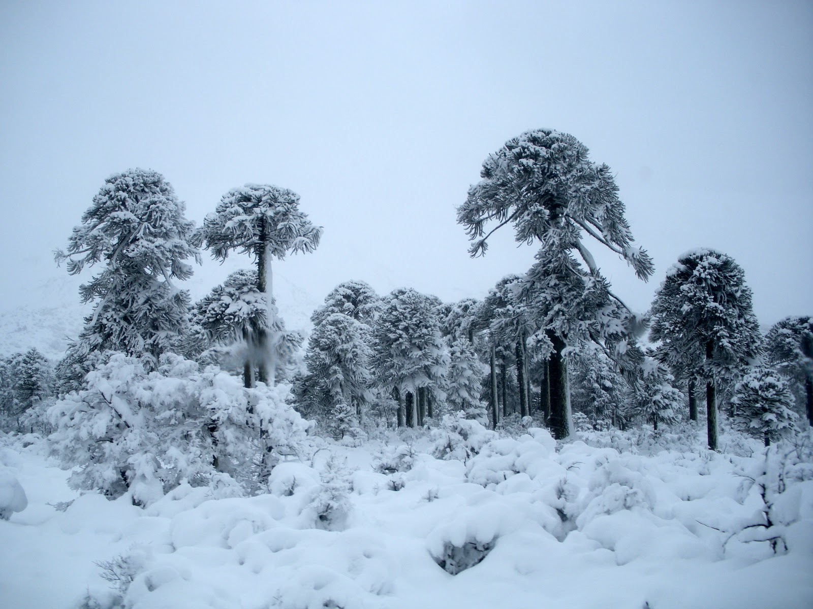
As we got closer to the border crossing, our road became narrower. In most sections two cars, let alone one of them being a buss, could just barely pass by each other. There was a point where a Subaru trying to get past us had to back up a quarter mile before finding a pullout on the road. We made our way around a series of sharp switchbacks to finally peak at the top of Mamuil Malal Pass. From there the road flattens out at about 4000ft elevation through forests of snow-covered araucarias trees at the base of the 12,200ft perfect cone-shaped volcano Lanin.

Man, I love araucania trees. Also known as monkey puzzle trees.

So much of the bus ride was through forests of these prehistoric looking trees.

The Argentinian and Chilean border crossing stations are about a mile apart from each other on an incredible road which winds around the snow-capped trees. I can't even compare this road to one in the states. It is just the tiniest international pass tucked into the mountains. It would be like taking one of the logging roads in the heart of the cascades in the middle of winter with a narrow semi-plowed road. In the summer when this place isn't in the snow, it is still just a primitive dirt road connecting Chile and Argentina.

As we continued over the Andes the road improved. One minute there is snow all over out my window and then the next minute it is all gone. It was the start of Patagonia, the rain shadow of the Andes. It wasn't long before we were driving through semi-arid deserts looking back at the Andes.

In the Andes...

Out of the Andes

The town of San Martin de los Andes was the next stop on my route. To get there, the road, which now resembles a modern highway, skirts along the eastern side of the Andes before heading back into the Mountains. I originally planned to just pass through San Martin, but since what was supposed to be a 4 hour bus across the Andes turned into an all day journey through the snow and Andean forests, I had to stop for the night and continue towards Bariloche in the morning.

Click to see a google map with my route through the Andes!


Read Part 2: Of the mountain towns of San Martin and Bariloche;