I left Chile a number of months ago in July, but I still have a large collection of my photos and stories from my journey across South America.
It was in early July, the middle of South America's winter, I finished my classes at the Universidad Austral de Chile. I left my host's house the day after classes at about five in the morning. Still a little bit drunk from saying all my farewells the previous night and working with only two hours of sleep, I grabbed my huge packs and gruelingly walked the two blocks in the pouring Valdivian rain to the bus station.
I was sad to leave the town of Valdivia, but still excited and somewhat nervous to start my the last leg of my trip towards Buenos Aires, Argentina. The previous week I had gone to the bus station to buy my ticket to Bariloche, a ski town just on the other side of the border, but I discovered that I could no longer cross to Argentina due to the current erupting state of the Puyehue-Cordón Caulle volcano. Using my Spanish skills which I had refined in my semester in Valdivia, I went around the many ticket booths at the bus station asking about alternate routes to Bariloche, Argentina. I've never been more proud of my Spanish skills than when I walked out of that bus station that day with a number of complicated bus passes and the satisfaction of knowing I throughly searched that bus terminal for the best prices and routes they had to offer.
 |
| A view of the eruption of Puyehue-Cordón Caulle which I shot from just outside Valdivia. This was the first day of a several month long eruption which closed airports across Argentina, South Africa, Australia, and New Zealand. |
Now, returning back to my early morning departure from Valdivia. I got on my first bus of the journey to take me to a small bus stop on the side of the highway two hours north. From there I nervously awaited my next bus across the Andes. My mom had given me the rule of no buses across the Andes in the middle of winter, but I didn't have much for other options. I'm sure not going to take a small prop-plane across the Andes (not just a because of the daunting stories of survival and cannibalism you hear about, but because volcanic ash was still closing local airports). I knew that the route between Valdivia and Bariloche was a perfectly safe mountain pass easily comparable to any highway going across my native Cascades Mountain Range, but that route was closed since it went along the base of an erupting volcano. I was hoping that the bus I was taking would be going over another major mountain pass. I was wrong.
 |
| This map shows the section of the Andes that I passed through to get to San Martin (bottom right). |
As the bus made its way from the lover central valley of southern Chile into the Andes Mountains, the torrential rain which had been going for a few days turned to snow. And soon that snow was piled up two feet high along the sides of the road. The bus had to stop for an hour as we waited for the snow plows to open up the pass to traffic for the day. As the bus went higher into the mountains, more and more snow was piling up on the road. Eventually, it came to the point where the driver asked everyone to move to the back of the bus to give the rear tires more traction. By this point I could tell that this wouldn't be just a quick trip across the pass.
 |
| The road to the border crossings blanketed in snow. |
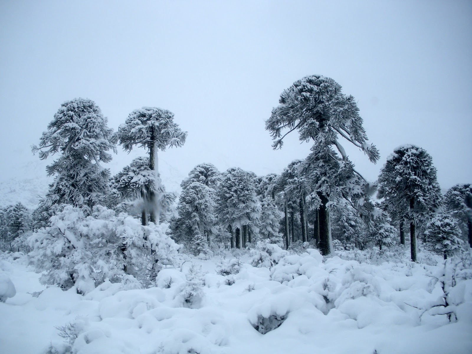
As we got closer to the border crossing, our road became narrower. In most sections two cars, let alone one of them being a buss, could just barely pass by each other. There was a point where a Subaru trying to get past us had to back up a quarter mile before finding a pullout on the road. We made our way around a series of sharp switchbacks to finally peak at the top of Mamuil Malal Pass. From there the road flattens out at about 4000ft elevation through forests of snow-covered
araucarias trees at the base of the 12,200ft perfect cone-shaped volcano Lanin.
 |
| Man, I love araucania trees. Also known as monkey puzzle trees. |
 |
| So much of the bus ride was through forests of these prehistoric looking trees. |
The Argentinian and Chilean border crossing stations are about a mile apart from each other on an incredible road which winds around the snow-capped trees. I can't even compare this road to one in the states. It is just the tiniest international pass tucked into the mountains. It would be like taking one of the logging roads in the heart of the cascades in the middle of winter with a narrow semi-plowed road. In the summer when this place isn't in the snow, it is still just a primitive dirt road connecting Chile and Argentina.
As we continued over the Andes the road improved. One minute there is snow all over out my window and then the next minute it is all gone. It was the start of Patagonia, the rain shadow of the Andes. It wasn't long before we were driving through semi-arid deserts looking back at the Andes.
 |
| In the Andes... |
 |
| Out of the Andes |
The town of San Martin de los Andes was the next stop on my route. To get there, the road, which now resembles a modern highway, skirts along the eastern side of the Andes before heading back into the Mountains. I originally planned to just pass through San Martin, but since what was supposed to be a 4 hour bus across the Andes turned into an all day journey through the snow and Andean forests, I had to stop for the night and continue towards Bariloche in the morning.
Click to see a google map with my route through the Andes!
Read Part 2: Of the mountain towns of San Martin and Bariloche;